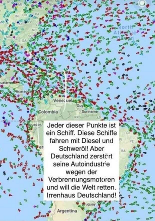
The basic statement is correct: every point on the Sharepic is a ship. But do they all run on diesel and heavy fuel oil?
The most important thing about this point = Ship Sharepic in brief
- On a sharepic you can see many dots that represent ships
- All of these ships will run on heavy fuel oil and diesel
- However, the so-called AIS signal is sent by almost all ships, including sailing boats and smaller boats
A sharepic shows a lot of small dots (triangles to be precise) that are swarming around South America. In the middle of the picture is the following text:
“Each of these points is a ship. These ships run on diesel and heavy oil! But Germany is destroying its car industry because of combustion engines and wants to save the world. Asylum Germany!”

already in July 2019 and October 2019 along with other, similar images from Australia and Africa/Europe that showed the same mass of dots.
[mk_ad]
Where does the picture come from?
Everyone can see this for themselves, because the picture is a screenshot from the “ MarineTraffic ” page. There you can see all the ships live, whose positions are recorded AIS signal ( A utomatic Identification System )
What is an AIS signal?
This signal is a radio signal and is sent out automatically by the radio devices. The aim is to not only transmit the position, but also other information such as ship type, etc. In this way, other ships should have the opportunity to plan and carry out their maneuvers well.
So Sharepic is right?
Only in the first sentence, these are really all ships. But that's about it, because it's really all ships that send out an AIS signal via the radio. This also includes, for example, sailing ships, which do not have to have an AIS transmitter, but do have one anyway because it is far better than radar (and you can be found quickly in the event of distress at sea).
[mk_ad]
Conclusion
The sharepic itself is real, but the claim is manipulative because, in addition to tankers and cargo ships, it also shows sailing ships or smaller ships with an AIS signal that are not powered by heavy oil or diesel.
Note : The radio devices with the AIS signal are only required for ships of a certain size. Therefore, not all small boats are recorded in MarineTraffic.
The degree of zoom also plays an important role. On the map you can see one icon for each vehicle, which is of course oversized when viewed globally. When you zoom in, it puts things into perspective a bit. In this respect, the global image looks like a “hidden object” because in this setting the icons move close together.
Notes:
1) This content reflects the current state of affairs at the time of publication. The reproduction of individual images, screenshots, embeds or video sequences serves to discuss the topic. 2) Individual contributions were created through the use of machine assistance and were carefully checked by the Mimikama editorial team before publication. ( Reason )

